
A large donation of over two hundred and fifty five rare maps of Persia and publications were donated to the School of Oriental and African Studies (SOAS), University of London, by an internationally well known scholar, Dr. Cyrus Ala’i. The donation, which will be referred to as ‘Dr Cyrus Ala’i’s Map Collection of Persia’, will be managed by the Archives & Special Collections section of the SOAS library. The donation was formally received by Professor Paul Webley, Director of SOAS, Dr Hassan Hakimian, Director of the London Middle East Institute and Dr Arshin Adib-Moghaddam, Chair of the Centre for Iranian Studies at a private ceremony on Thursday 31 January 2013. A public event to celebrate the donation will be announced later in the year.
SOAS, University of London (The School of Oriental and African Studies) is the only Higher Education institution in Europe specialising in the study of Asia, Africa and the Near and Middle East. SOAS is a remarkable institution. Uniquely combining language scholarship, disciplinary expertise and regional focus, it has the largest concentration in Europe of academic staff concerned with Africa, Asia and the Middle East.
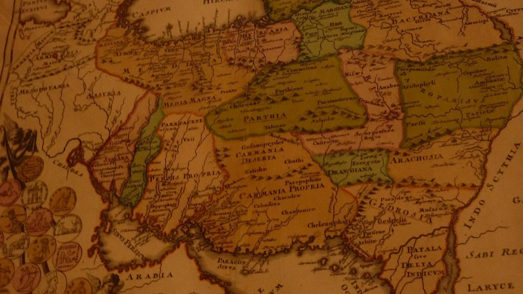
CYRUS ALAI was born in Iran and received his PhD degree (Dr.-Ing.) from ‘Technische Universität, Berlin-Charlottenburg’. He completed the ‘Executive Controls Program’ – a management course – at the University of Syracuse, USA, and lectured at the University of Teheran for eight years. Dr. Alai founded a group of engineering companies in Iran, which he directed for twenty years. He settled later in England, working as a consulting engineer and studying history of cartography in his free time. He served nine years as the honorary treasurer of the International Map Collector’s Society (IMCoS), and wrote numerous articles and gave many lectures (including one at SOAS on 8th NOV 2006 at the Khalili Lecture Room. organised by SOAS and Iran Heritage) on ‘the cartography of Persia’ and ‘the traditional cartography of classical Islamic societies’. His articles (in English and Persian) appeared in several prestigious cartographic and cultural periodicals, such as: Map Collector, IMCoS Journal, Mercator’s World, Portolan, Journal of the Iran Society, Iranshenasi (Persian), Rahavard, etc. The entry ‘Geography iv, Cartography of Persia’ in the Encyclopaedia Iranica, has been written by him. He also collected old maps of Persia and owns perhaps the largest personal collection of such maps. Dr. Alai recognised that Persia has been mapped extensively for centuries but the absence of a good map-history and carto-bibliography has often deterred scholars from making use of such maps. Therefore, he embarked on a lengthy (about 20 years) investigation into the old maps of Persia and visited major map collections and libraries in many countries. As a result, he produced a monumental work in two volumes: General Maps of Persia, 1477-1925 appeared in 2005, and Special Maps of Persia in 2010, both published by BRILL in Leiden, The Netherlands.
Publisher’s Commentary
Iran, or Persia as it was known in the West for most of its long history, has been mapped extensively for centuries but the absence of a good cartobibliography has often deterred scholars of its history and geography from making use of the many detailed maps that were produced. This is now available, prepared by Cyrus Alai who embarked on a lengthy investigation into the old maps of Persia, and visited major map collections and libraries in many countries. With over four hundred separate map entries and over two hundred illustrations this work covers all the important printed general maps of Persia from the early editions of Ptolemy at the end of the 15th century until 1925 when the Qajar dynasty was overthrown. Useful historical accounts provide the background to this wealth of cartographic achievement. After a description of the many editions of Ptolemy, later maps are divided into groups according to the country where they were produced: Italy, the Low Countries, France, Germany, Great Britain, Russia, America, Persia, Turkey, and Spain with Portugal. This permits the work of a single cartographer to be handled in an uninterrupted sequence, thus aiding quick reference to a particular style of map, and its later offshoots.
At the end of each major entry, further details concerning different editions and variations, other related maps, historical notes and unique or important features are provided, thus fitting the map into its chronological background. The large number of indexes at the end of the book should enable map collectors, dealers and librarians to identify any map of Persia with ease.
This book is a good balance between history and geography, and will appeal to a wide range of readers. Many Persian maps have surely been rescued from obscurity, and it is now possible to study sequence of developing geographical knowledge over a historically and economically important part of Asia. It is unlikely to be superseded for a very long time.