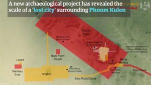
 Using laser technology, archaeologists in Cambodia have found multiple, previously undocumented medieval cities, as reported by the Guardian newspaper and several other news outlets. These cities which are not far from the ancient temple city of Angkor Wat, would have made up the world’s largest empire in 12th century.
Dr Damian Evans, an Australian archaeologist led the team of archeologists who captured and gathered the data in 2015 during the most extensive airborne archeological study ever undertaken. The data was just recently analyzed and will be published in the Journal of Archaeological Science in the next few days. The team has announced that cutting-edge airborne laser scanning technology has revealed multiple cities between 900 and 1,400 years old beneath the tropical forest floor, some of which rival the size of Cambodia’s capital, Phnom Penh. The data shows that the colossal, densely populated cities would have constituted the largest empire on earth at the time of its peak in the 12th century.
Dr. Evans has received European Research Council (ERC) funding for the project, based on the success of his first lidar (light detection and ranging) survey in Cambodia in 2012. That earlier project uncovered a complex urban landscape connecting medieval temple-cities, such as Beng Mealea and Koh Ker, to Angkor, and confirmed what archaeologists had long suspected, that there was a city beneath Mount Kulen. It was not until the results of the significantly larger 2015 survey were analyzed that the size of the city was apparent according to the Guardian newspaper. Archeologists uncovered in the earlier survey that elaborate water systems that were built hundreds of years before historians believed the technology existed. The findings are expected to challenge theories on how the Khmer empire developed, dominated the region, and declined around the 15th century, and the role of climate change and water management in that process.
The team explains that they fired lasers to the ground from a helicopter to produce extremely detailed imagery of the Earth’s surface. Evans said the airborne laser scanners had also identified large numbers of mysterious geometric patterns formed from earthen embankments, which could have been gardens.
The Angkor temple ruins, which expand across the UNESCO-protected Angkor archaeological park, are the country’s top tourist destination, with the main temple-city, Angkor Wat, appearing on the Cambodian national flag. Experts in the archaeological world agree that these are the most significant archaeological discoveries in recent years.