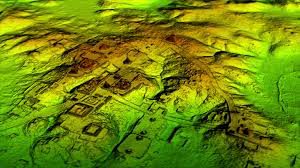
 As reported by a number of news outlets including the National Geographic, airborne laser scans have helped archeologists and researchers to uncover a vast Mayan ’megalopolis’ with tens of thousands of buildings including pyramids under the jungle in Guatemala.
As reported, the remains include canals and industrial-sized fields, and suggest that millions of people may have lived in the area.
The remains lay hidden for centuries, but were detected using airborne light detection and ranging technology, or LiDAR. This exciting discovery which has been possible using technology has allowed researchers to use high-tech mapping of the site and these findings suggest that over then million people may have lived in a lost city in modern day Guatemala. This site was until the discovery unknown and now reveals communities and city where thousands of interconnected structures in Guatemala’s jungles, including houses, farms, highways, and pyramids were constructed.
According to the researchers, the find suggests that the area may have been home to more than 10 million people, and that at its peak 1,500 years ago, the Mayan civilization was more advanced than Chinese or Greek cultures. In addition, it looks like that they had built huge defensive walls and fortresses which were uncovered in the area and also suggest a long history of war. The archeologists believe that this finding is one of the greatest advances in over 150 years of Maya archaeology.
The new site includes urban centers with sidewalks, homes, terraces, ceremonial centers, irrigation canals and fortifications and researchers believe that if the technology was not utilized and they had simply used the classical archaeological method, they would not have finished and revealed all they have found in their lifetimes. It is so amazing that for the Guatemala project, the LiDAR information was gathered over the course of eight days and 44 hours of flight and involved 38 billion laser pulses. The plane used to fly over the area was equipped with a state-of-the-art multispectral Titan MW LiDAR sensor, based on specifications requested by NCALM and developed by Teledyne Optech. Airborne LiDAR is a remote sensing technology used to produce high resolution three-dimensional maps using lasers and it works by firing hundreds of thousands of laser pulses per second from an aircraft flying at a relatively low altitude; a timing device measures the round-trip travel time, using that information to create detailed topographical maps.